News - July, 2022
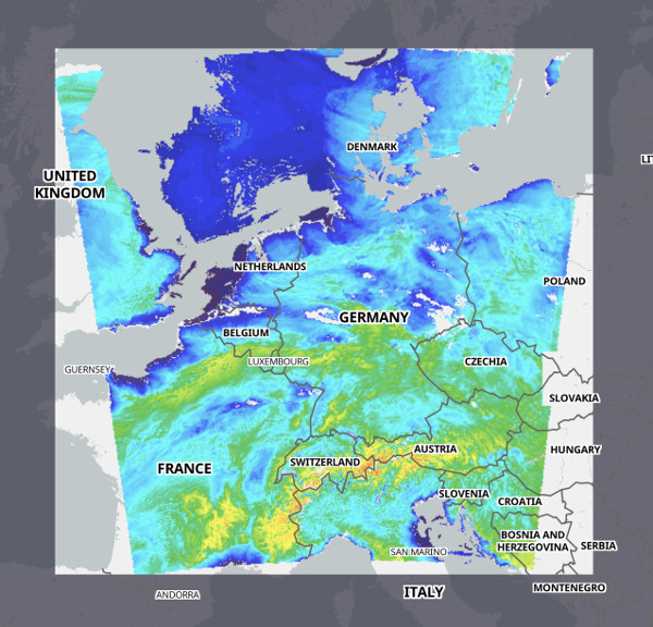
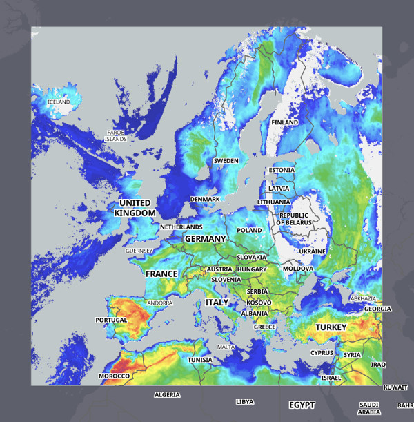
XC Skies is excited to announce two new high resolution models for France and Central Europe. These are the ICON D2 2.2km and the Arome 2.5km. The ICON nested European model is also available at 6.5km
Arome 2.5km coverage

ICON D2 2.2km coverage
ICON European 6.5km coverage
XC Skies Soaring Forecasts
Project Highlights
• Interactive soaring forecast maps and tools for virtually every flyable location on planet Earth.
• Our goal is to provide timely and highly useful soaring forecasts to allow pilots to make better decisions on when and where to fly.
• XC Skies is enabling pilots to break their personal bests and smash records by providing detailed soaring parameters that allow area, point, and route cross-section analysis.
• Pilots can visualize forecasts with our interactive maps and XC exploring tools to investigate the potential trends over the next upcoming days.
Mission
Our mission is to provide timely and useful global soaring forecasts which are always available to pilots via the web through a variety of interactive tools.
How it Works
XC Skies creates visual layers of basic soaring parameters, wrapped up in an interactive application that can be used with any popular browser over the Internet. You can use XC Skies from anywhere in the world! By running our code and algorithms against the forecast model output from NCEP and other sources, we can parameterize essential soaring elements that are critical to understanding soaring conditions.
Features
• Leverages a Web Browser Map framework to provide very useful geo-references.
• Users can save as many profiles as they like to quickly assess predefined regions. A default profile can be selected, allowing the application to automatically load with the parameters and location saved.
• Investigate any point by clicking anywhere on the map. Review soundings via an interactive Skew-T application for both model output and the most recent balloon sondes released across the planet.
• Analyze 3+ day point forecasts by clicking any location on the map. These time-height plots show a tremendous amount of information in a simple to read graphic format.
• Review soaring forecasts along routes and trend the day along a track.
Screenshots and Examples
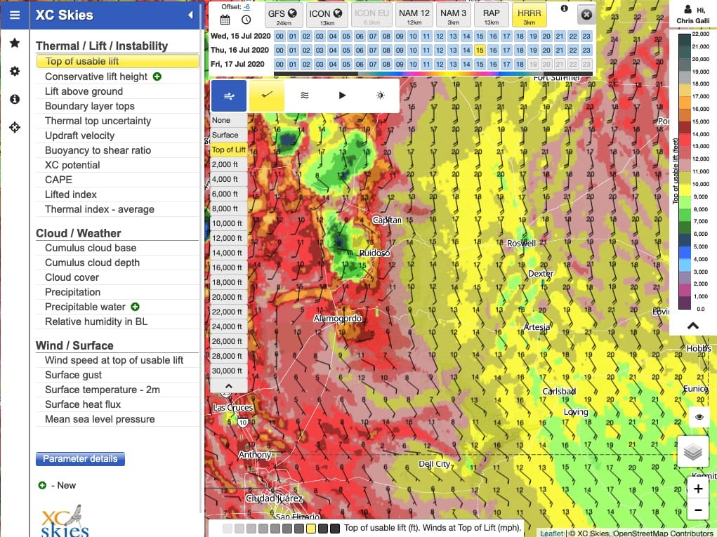
By default, useful soaring parameters show as layers on fully interactive maps. These quick views are the entry point into further reviewing details of the soaring potential for any forecast time and location.
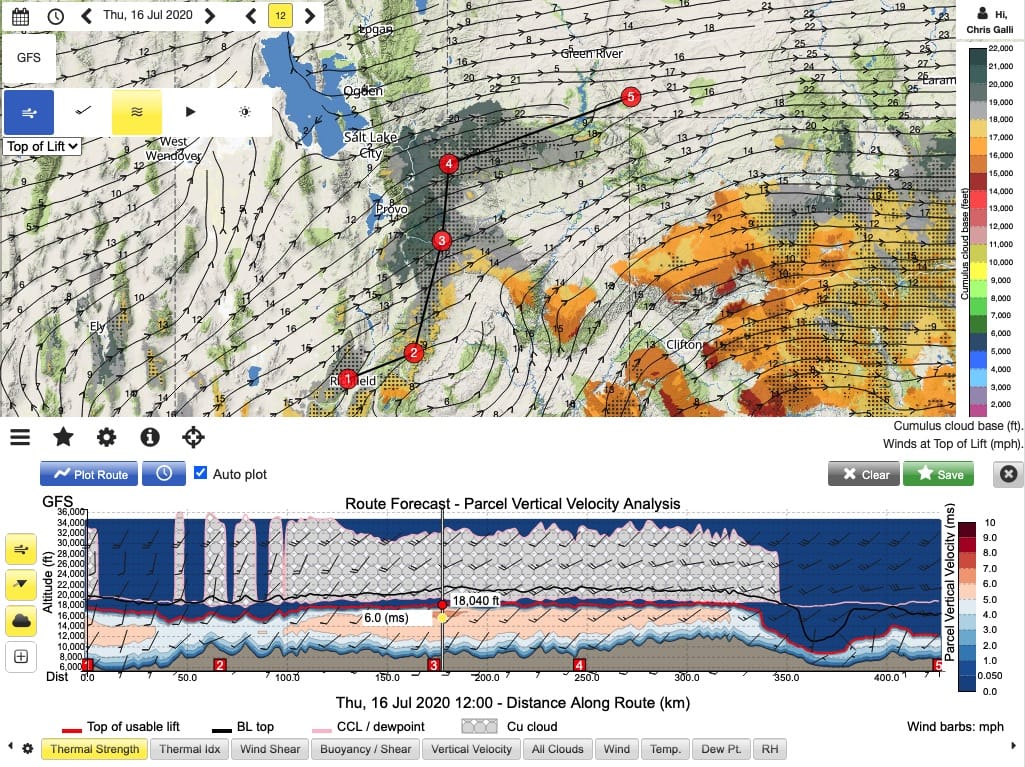
Build routes on the map to review the vertical details along the path. Use the time options to indicate a start and end and see how the day evolves along a route.
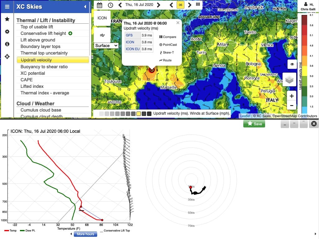
For Skew-T enthusiats, a single click allows quick review of the temperature and dew point profiles and any location and time.
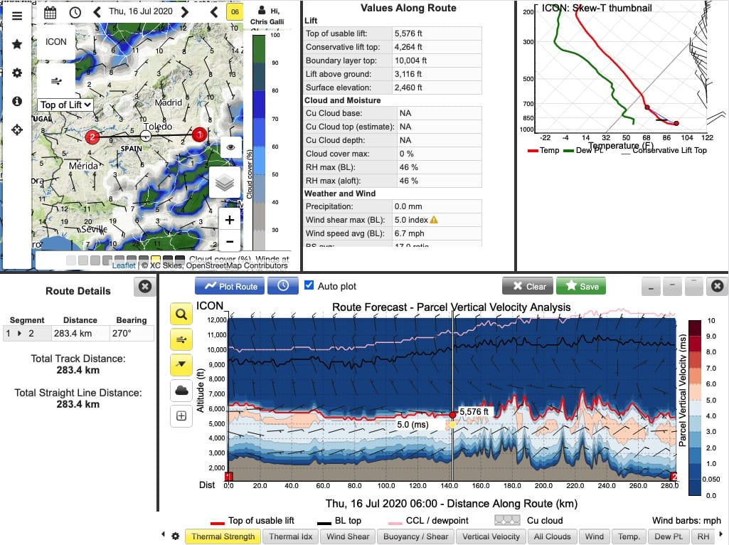
Detailed reviews of routes or point forecasts allows a comprehensive look into soaring potential details and weather threats alike. With Skew-T plots for every moment on the lower panel plots, review of the internal structures of lift potantial and RH (clouds and thunderstorms) is simple.
- GFS. A global model at roughly 24km resolution run by NCEP in the United States. Updated every 6 hours.
- ICON. A global model at 13 km resolution run by DWD, the German weather service. Updated every 6 hours.
- ICON EU. A 6.5 km resolution model including all of Europe. Updated every 6 hours.
- ICON D2. A 2.2km resolution model across central Europe and the Alps. This model is based on the German DWD ICON global model and runs out to 45 hours.
- RAP. A 13 km resolution model across the continental United States. Updated hourly.
- NAM. A 12 km resolution model across the continental United States. Updated every 6 hours.
- NAM Hires. A 3km resolution model across the continental United States. Convective resolving and updated hourly.
- HRRR. A 3km resolution model across the continental United States. Based on the RAP and known as the High Resolution Rapid Refresh model. Convective resolving and updated hourly for 18 hour forecasts.
- AROME. A 2.5km resolution model run by Meteo France centered over France covering much of Spain and surrounding areas. This model runs out to 36 hours.
